BWCA Entry Point, Route, and Trip Report Blog
May 14 2024
Entry Point 52 - Brant Lake

Brant Lake entry point allows overnight paddle only. This entry point is supported by Gunflint Ranger Station near the city of Grand Marais, MN. The distance from ranger station to entry point is 45 miles. Access is a canoe landing at Round Lake with an 85- and a 35-rod portage to Brant Lake. This area was affected by blowdown in 1999.
Number of Permits per Day: 4
Elevation: 1500 feet
Latitude: 48.0692
Longitude: -90.8455
Brant to Tuscarora via Little Sag Route:
Round
Brant
Bat - Mud
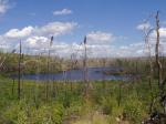
Gillis - burn area is evident:
French
Peter - first lake trout:

Virgin
Little Sag - green trees again!
Mora - gorgeous divide of burn and green
Crooked
Owl
Tuscarora - second lake trout!
Missing Link - with lighter food pack, the portage is OK
Round
Number of Permits per Day: 4
Elevation: 1500 feet
Latitude: 48.0692
Longitude: -90.8455
Brant to Tuscarora via Little Sag Route:
Round
Brant
Bat - Mud
Gillis - burn area is evident:
French
Peter - first lake trout:
Virgin
Little Sag - green trees again!
Mora - gorgeous divide of burn and green
Crooked
Owl
Tuscarora - second lake trout!
Missing Link - with lighter food pack, the portage is OK
Round
8-day to Cross Bay Lake - May/ June 2020
by ghamer
Trip Report
Entry Date:
May 26, 2020
Entry Point:
Cross Bay Lake
Number of Days:
8
Group Size:
5
Trip Introduction:
We entered at Cross Bay Lake and leisurely traveled through Ham, Snipe, Cross Bay Lake, Rib to Long Island Lake. Very easy pace, with much time for exploring, fishing and photography! We saw moose, trumpeter swans and even had a tame snow shoe hare at one camp site :-) The YouTube slide show reduces our 8-day trip down to 14 minutes.
Report
discuss this trip report (15 comments) - last post on July 10, 2020