|
 Boundary Waters Quetico ForumFishing ForumGPS, depth finder, and how would you fish this spot?
|
 Forum Sponsor

Author
Text
")

06/19/2020 08:01AM
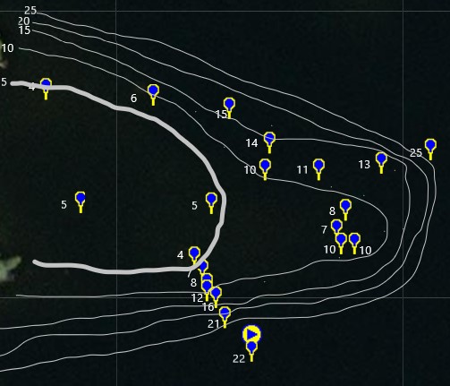
On a recent trip, I found a 4' deep spot quite a ways from shore. I mapped a bunch more depths and stored them on my GPS. The resulting contours look nothing like the published contours.
I fished the spot and caught some really nice smallies and walleye.
This shows the advantages of bringing a depth finder...
But... I don't think I fished the spot very well. How would you fish this spot for walleye and smallies??? (The area shown is right next to shore. The left edge is shore. Also, the spot shown is about 400 feet across)
Fish where the fish are...

06/19/2020 03:14PM
I'm not an expert, but how I would fish it in a canoe depends on wind direction and wind speed and if I have my basketball net/rock anchor with me.
Sounds like you found them at a certain depth. I would just focus on that approximate depth range. Generally windward side for walleye, look for structure/boulders or transition areas.
What were those coordinates again?
Sounds like you found them at a certain depth. I would just focus on that approximate depth range. Generally windward side for walleye, look for structure/boulders or transition areas.
What were those coordinates again?
06/20/2020 09:40AM
arnesr: "I'm not an expert, but how I would fish it in a canoe depends on wind direction and wind speed and if I have my basketball net/rock anchor with me.
Sounds like you found them at a certain depth. I would just focus on that approximate depth range. Generally windward side for walleye, look for structure/boulders or transition areas.
What were those coordinates again?
Nice Try Arnesr!!
You're going to HELL and you're going to drag me with ya!! -Gunsmoke
06/24/2020 04:52PM
This message has had HTML content edited out of it.
A lot of how to interpret electronics and, more importantly, how to fish the area found using them, depends of several factors. I'd say the 1st thing to consider is current. If you are familiar with river fishing for smallmouth or trout you'll get what I'm about to say instantly. Imagine you are fishing a river and there is a gravel hump, or shoal, jutting out in to the river. Fish will sit on the backside of that shoal in the "current break" and wait for schools of bait fish that get caught in the current pushing up and over the shoal. You'd be wise to imagine the fish siting on the contour break - facing into the current, on the backside. Next, I'd consider the proximity of the "point" that you've located to deep water. Your graphic is lacking in that detail, but let's just assume the deepest water in the area is on the north side. In the absence of current, or with a South to North current, I would focus my efforts on the Northern side of the point.
Establishing the side of the break you expect fish to be on, you have 2 choices, IMO. Anchor on the shallow of the point and start casting out and across that northern break. Make your way out across the center of the point, or perhaps on the Southern side if its a really narrow point, until you determine the depth the fish are sitting at. Or, start deep and make your way in. Much of this depends on whether you have an anchor and what lures your throwing. I like to crank points and for that method I try to position the boat parallel to the break and fish a constant depth.
BTW...as for determining current. If water is coming in one side of a lake and exiting another - you have current.
Hope this helps. If you tell me EXACTLY where your hot spot it, I'm sure it'll help me explain it better.
P

01/20/2021 09:50AM
cyclones30: "Are those your drawn contours? They don't seem that far off of the points. But yes it all depends on the wind that day. Drift it and see what you find a few times over and then narrow down from there "
I'm sorry for the confusion. Those are contours that I drew based on my depth measurements.
The published contours were very different.
Fish where the fish are...
")
01/20/2021 11:25AM
If you are asking about a lake in the BWCA, then those lakes were plotted by hand drawn maps using a weight and string decades ago. Most have never been updated. Every map drawn today just copied the original maps that were drawn way back then. Today’s electronics and GPS locations are totally different. Stone Age vs space age.
I would focus on the flat 8-10 and the point on the right. Stay in 8-18’ FOW.
I would focus on the flat 8-10 and the point on the right. Stay in 8-18’ FOW.
"So many lakes, so little time." WWJD
01/20/2021 01:52PM
I once found a 4’ flat that had emergent weeds at the break. A key factor in catching fish was a stealthy approach. We caught all the walleye we wanted on the edge, and occasional smallmouth in the weeds. Too much disturbance, and the bite was over.
Fritty
Fritty
05/16/2023 02:10PM
I would anchor at the 10' break at the end of the longest point. Cast bottom bumping lures such as a bucktail jig, a tube lure, blade bait or a chatterbait with a plastic trailer out into the deeper waters off of the end and bounce them back up the face. Maintain contact with the bottom for the whole retrieval. When the fish move shallow to feed, they will travel from the deep water up towards that point. Sun penetration (clouds and/or windy conditions) and water clarity will determine how shallow they will move on any day.
Good luck.
SE
Good luck.
SE
Outside of a dog, a book is man's best friend. Inside of a dog is too dark to read.

Subscribe to Thread
Become a member of the bwca.com community to subscribe to thread and get email updates when new posts are added. Sign up Here
Community Links
 Search BWCA.com
 Donate
 Featured Sponsor
