|
05/24/2022 07:25AM |
|
05/24/2022 10:57AM |
thatsapaddlin: "How swift is the current on LIS? We have a group heading in next week, and I'm wondering how difficult it will be to paddle out against the current. Thanks!"
Entered LIS 5/13, exited 5/20. River was high for sure. Portage at Devils Cascade was flooded, making the landing tricky. We lined the canoes along shore to get to the trail. The group in front of us decided to turn around and not take the risk. Definitely use caution here. A trip over the falls will not end well. Going back up LIS was business as usual- a little current near the entry.
Pete
|
05/24/2022 11:26AM |
sueb2b:
Back on Shell I saw two guys fishing. Had seen another canoe with two people; could have been the same folks. I was kind of far my first pass by. Today’s been a rest day. Haven’t seen anyone. "
Im 95% positive that was us fishing and in the other canoe! We stayed on Lynx Saturday-Tuesday, then packed up and went to Shell Wednesday and stayed until leaving Thursday. Pretty neat.
|
05/18/2022 02:37PM |
My map shows the LIS portage (midway to Upper Pauness) on the west and Devils Cascade on the east, is that correct?
I am keeping all options open if I feel uncomfortable with the conditions. Thanks in advance for any input from folks who have been that way before.
|
05/22/2022 06:00AM |
sueb2b: "The mudpit formerly known as the Shell portage beaver pond.

And then the trees.
"
Thanks for taking the time and letting folks know this info, Sueb2b!
|
05/28/2022 10:24AM |
I wet footed with Keen's and wool socks the whole trip.
I'll put together a trip report later this weekend, but I just wanted to share this for anyone on fence about this EP. High water was not an issue.
It was an absolutely fantastic trip!
|
05/21/2022 10:32PM |
And then the trees.
|
05/24/2022 11:29AM |
Reach out with any questions
|
05/19/2022 09:50AM |
|
05/19/2022 10:52AM |
|
05/19/2022 03:13PM |
Also, I saw someone said the water was too cold for leeches currently.... Anyone know anything about this?
|
05/19/2022 07:01PM |
ThreeRivers: "Wow, awesome! You got a sat phone? I never get (or care to) get cell coverage on my trips."
Just an iPhone. I took it off airplane and was surprised to have service. It’s not much, and don’t always have it. I can text and interact a few places like here. Definitely not something to rely on.
As for crowds, I was on Shell Monday night and I think I saw one occupied site. I’d seen one occupied site on Lower Pauness, but I wasn’t checking all sites on any lake. On way to Heritage on Tuesday I saw two hikers on SHT. Tuesday at least one, maybe 2 other sites on Lynx were occupied. I heard some voices entering lake, and saw a guy in a solo canoe checking out the Little Shell portage. Back on Shell I saw two guys fishing. Had seen another canoe with two people; could have been the same folks. I was kind of far my first pass by. Today’s been a rest day. Haven’t seen anyone.
|
05/19/2022 02:50PM |
|
05/19/2022 06:50PM |
sueb2b: "7039412108: "I was there in October and the beaver dam was still there. Going in on Sunday. With the high waters not sure what I will find....."
I’m on Shell right now. Any questions, let me know.
Went Upper Pauness > Lower Pauness > Shell > Heritage > Lynx, and then back to Shell through Heritage. "
How are the crowds your way?
|
05/25/2022 02:17PM |
|
05/18/2022 04:30PM |
The 8 rod portage between Upper and Lower Pauness was a wide, fast set of rapids on Monday. I considered portaging through the campsite on the north side, but I didn’t like the fast water where it empties and the fact I couldn’t tell where any obstructions might be. I took the 40 rod portage. It was muddy, but not bad.
I heard the Devil’s Cascade portage out of Lower Pauness was difficult due to the water. I haven’t seen it so can’t say for sure. I might stop by Friday to get a pic.
If you’re going into Shell, let me know. That portage is a mess.
|
05/18/2022 03:14PM |
|
05/18/2022 05:13PM |
I could see the portage landing to Devils Cascade/Loon being one to watch. The normal landing isn't far from where it necks down and picks up speed. But you have plenty of time and lake to hug the right hand shore as you're approaching. Just be sure to pull the canoes well up when landing as you don't want the wind or current or weight of packs taken out to let a boat start downstream.
|
05/20/2022 02:49PM |
|
06/04/2022 10:45AM |
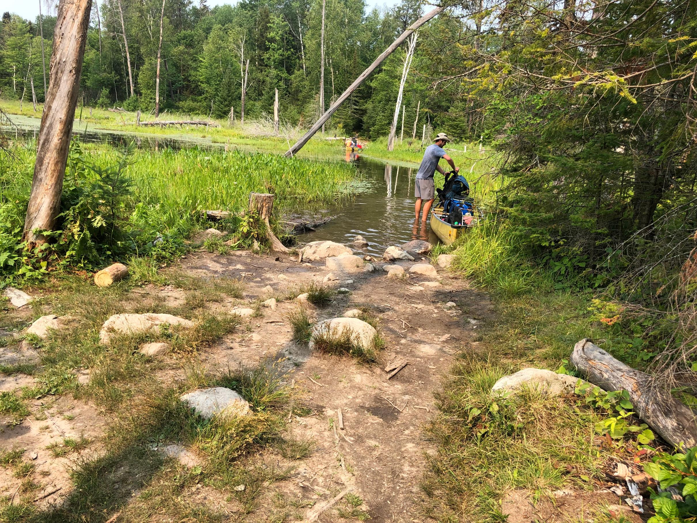
Once you land you might have to walk a bit on water since the path is under water but no major issue if you're careful.
Here is a link to a short video you can get a better sense:
Video of Devils Cascade portage as of end of May 2022
|
05/21/2022 06:57AM |
This was last year July the day they shut down #14 entry point. It was less than knee deep. I imagine you may have to paddle it right now.
|
05/22/2022 09:12AM |
|
05/18/2022 09:55PM |
I got to a point in the mud where I thought the process of pulling my sandals up with each step was going to pitch me face first into it all. I put the canoe down on one of the boardwalks, went to dry land to drop my food pack and left the sandals there, and went back for canoe in my socks. Then, took the dam back to start to get my gear pack, carrying sandals on a stick to wash them. Used dam route on way back to canoe.
Now before you get to the mudfield, part of the route is a big granite rock face. Unless they get cleared, there’s a couple big birch trees blocking the path. I ended up going into the woods on left (would be on right from Shell) to get past and back to the portage path.
Coming from Shell you’ll hit the trees then the dam. Get through those and the remaining 2/3rds or whatever of the portage weren’t very memorable. Probably wet in places. Everything is wet in places.
|
05/19/2022 09:13AM |
|
05/18/2022 08:18PM |
Sueb2b - I will be doing a clockwise loop, so I will come the out thru Shell at the end of the trip. Sounds like a little adventure to close out the week, at least my pack will be lighter by then and maybe things will have time to dry out a little bit. Thanks also for the heads up on Upper to Lower portages, I'll keep that in mind.
703 - I'm going in Sunday as a solo as well. Perhaps we'll cross paths at the EP or during the week. Safe travels!
|
05/19/2022 09:38AM |
I would have preferred the beaver pond to the mud pit.
But, I got through it solo. So it’s not impossible or impassible. Just takes time and care figuring out a route through the obstacles.
|
05/19/2022 10:02AM |
7039412108: "I was there in October and the beaver dam was still there. Going in on Sunday. With the high waters not sure what I will find....."
I’m on Shell right now. Any questions, let me know.
Went Upper Pauness > Lower Pauness > Shell > Heritage > Lynx, and then back to Shell through Heritage.
|
05/20/2022 06:52PM |
For Upper to Lower Pauness it’s muddy and can be slick. The short portage was a wide river on Monday so I did the other (40 rod?). Other than the muddy/slick no issue.
I looked at Shell to Little Shell. Lots of rocks on approach. I didn’t want to rock hop my gear though water; I’m not that sure footed. I went to Heritage, which was easy but half is a stream. Then Lynx. Again, some water on that one but nothing difficult.
My biggest battle today was paddling into the wind. Coming in on LIS the wind from the north was more a factor than high water.
|
05/20/2022 09:12PM |
|
05/18/2022 05:06PM |
Just talked to the Piragis Outfitters that I regularly use. No issues on driving thru Echo Trail all the way to the parking spot on EP 14. It seems other roads on the East side are closed due to flooding. He mentioned to expect some muddy portages but no major issues.
I will report what I find on or about Memorial Day.
|
05/18/2022 06:03PM |
cyclones30: "The valley from the EP to the pauness area is pretty wide so it would take a TON of water to make that an issue. You'll get from the EP to the first lake faster than most years! But that portage along the river is very scenic normally, take your time and take some pictures. It is on the left yes.
"
On Monday the wind from the north made the going off the portage a little slower than you might think due to the high water. The wind seemed like more a factor against me than the current was for me.