|
 Boundary Waters Quetico ForumListening Point - General Discussion south lake campsite closures UPDATED
|
 Forum Sponsor

Author
Text
")


06/22/2016 06:51PM
can't seem to paste a map or pdf file so the best description is:
the 3 sites along the west side of lake to the left of the height of land portage.
the first site to the east of the topper lake portage.
work is being done to reopen the sites. no reduction in permit quota for EP 58 South lake or EP 60 Duncan lake at this time.
the 3 sites along the west side of lake to the left of the height of land portage.
the first site to the east of the topper lake portage.
work is being done to reopen the sites. no reduction in permit quota for EP 58 South lake or EP 60 Duncan lake at this time.


")
06/22/2016 11:16PM
Thanks Mocha for the info.
Wonder how much tree damage took place. The site to the right of the portage facing the lake you would of thought would of been protect from like any south wind.
Wonder which direction winds were up there. Did it blow from the northwest.
Wonder how much tree damage took place. The site to the right of the portage facing the lake you would of thought would of been protect from like any south wind.
Wonder which direction winds were up there. Did it blow from the northwest.
06/22/2016 11:24PM
quote brux: "I was at the campsite on the south shore of South over Memorial Day weekend. That site had some massive trees. I can't even imagine what it would have been like with some of them coming down..."
Some of those white pine must be 300 years old. It will be interesting if still standing. It is a moment for thought-something can be standing and growing since we became a country and potentially in a few seconds may be gone.
As also the tragic loss of life on Duncan,happened so fast.
06/23/2016 06:29AM
quote Pinetree: "Thanks Mocha for the info.
Wonder how much tree damage took place. The site to the right of the portage facing the lake you would of thought would of been protect from like any south wind.
Wonder which direction winds were up there. Did it blow from the northwest.
"
I was on North Lake yesterday morning. The area between the west end of North and South lakes received extensive damage. Almost every tree is down or missing its top. I talked to some guys camped on one of the little islands on North. They said it sounded like a train going through. There was a nice pine plantation on that ridge from the CCC days. I'm sure that's destroyed as well.
"Man's heart away from nature becomes hard." Standing Bear
06/23/2016 08:23AM
? I thought I posted on this but guess I hit the wrong button (LOL)? Stayed in that last one and we actually stayed there for two days BECAUSE of bad weather. Scary to think of how bad that storm must hav been?
"Let us live so that when we come to die even the undertaker will be sorry." Mark Twain
06/23/2016 01:21PM
From the Forest Service today:
Our updated conditions report for South Lake is that only one campsite is open at this time (far western side of lake).
The only access in to South Lake is from Topper; the route to Rat Lake is impassable.
Two to three crews will be working to clear campsites and portages and assess further damage.
We’ll keep you updated as information comes in -
06/23/2016 02:28PM
quote inspector13: "quote ozarkpaddler: "? I thought I posted on this but guess I hit the wrong button (LOL)?"
In a way you did; but in a different forum.
"
So THAT'S what happened (LOL)? Thanks, I thought my mind was getting worse! Gosh that was one nasty storm
"Let us live so that when we come to die even the undertaker will be sorry." Mark Twain
06/23/2016 03:36PM
quote Mocha: "
From the Forest Service today:
Our updated conditions report for South Lake is that only one campsite is open at this time (far western side of lake).
The only access in to South Lake is from Topper; the route to Rat Lake is impassable.
Two to three crews will be working to clear campsites and portages and assess further damage.
We’ll keep you updated as information comes in -"
Thanks for the info.
For me that it one of the prettiest areas in the BWCA. Like I said earlier I hope those 300 year old pines and huge cedar trees made it.
06/23/2016 04:07PM
quote Pinetree: "quote Mocha: "
Thanks for the info.
For me that it one of the prettiest areas in the BWCA. Like I said earlier I hope those 300 year old pines and huge cedar trees made it."
My opinion also. The thread last week asking about your "Last trip" I mentioned this route as being my choice.
"Let us live so that when we come to die even the undertaker will be sorry." Mark Twain
06/28/2016 07:04PM
update:
the portages from North to South (height of land) is open, south to rat is open, rat to rose is open, stairway portage is open. the long portage is NOT open, however, people have muscled through and it took up to 4 hours to make it to the split.
duncan has just one site closed. rose has one site closed. no new permits will be issued for south lake until more sites on south are opened. apparently there are 4 sites open now but not sure which sites.
the border route hiking trail, as described by some through-hikers, was a big mess from the daniels spur/split to beyond partridge lake.
not sure if anyone other hikers have been through.
caribou rock trail from HJ road to overlooks is good, but beyond to duncan and rose not so good.
bring extra saws!
06/29/2016 01:13PM
these photos taken from the overlook on the border route hiking trail near Topper lake.
 north shore of south lake. the first bay on the left leads to the height of land portage to north lake.
 north shore of south lake, near the west end of south lake.
 north shore of south lake. north lake in background
 north shore of south lake. the first bay on the left leads to the height of land portage to north lake.
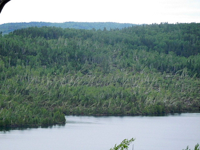 north shore of south lake, near the west end of south lake.
 north shore of south lake. north lake in background
06/29/2016 05:54PM
quote nojobro: "Is this the only area with many trees down?"
nola, no, this is not the only area, just the area the camera was able to capture. there are trees down from the east end of gunflint lake (near bridal falls area) all the way to the split on the long portage (the split has you decide to go to Rove or the Daniels). there are trees down along the portage to Rove. there are also trees down along the pine portage from canoe to pine lake (east bearskin area).
06/29/2016 08:50PM
quote maddowg1192000: "What site on Duncan is closed?"
See the map at the top of the thread. It's the 3rd site on the north shore, moving west from Stairway Portage.
Just got back from a short trip to Duncan...stayed at the site northeast of the closed site...lots of storm damage but the site had been cleared and was useable if a little messy and probably smaller than it was previously. Lots of storm damage visible around the lake and also on Rose visible from the overlook.
07/02/2016 01:29PM
the portages are cleared almost all the way through the long portage. that is still being worked on but it is passable with careful portaging.
all sites on ROSE are open now.
this is the current news from the USFS: "The Caribou Rock Trail, located in the mid-Gunflint Trail area, experienced extensive damage between the portage from West Bearskin Lake to Duncan Lake and the Stairway Portage. The trail is extremely difficult to follow in this section. Hikers are encouraged to evaluate their physical fitness and orienteering skills prior to hiking this section of wilderness trail. The beginning of the trail between the Caribou Rock Trailhead and the portage from West Bearskin Lake to Duncan Lake is in good condition with very few trees down. It is unknown at this time how the storm effected the Border Route Trail. "
08/02/2016 06:26PM
as of a few days ago, there are just 2 sites still closed on south lake. one is on the east end near the portage to Rat lake and it also has the spur trail up to the border route. that spur has not been cleared, nor has the site. so sad as that site had some wonderful huge trees. the other site still closed is the middle site of the group of 3 near the portage to north lake.
i saw today the USFS is closing the first 15 miles of the Kekakabic out of Snowbank. i'll try to find more info on that closure.
 this is what the trees looked like (and many much larger) on the far eastern site of south lake. not a lot of understory, long hike up to the latrine, huge cliff hidden by trees and really flat on top, spongey with moss carpet
the closed site on Duncan has been reopened.
work is happening on the closed site on Clove lake.
work is also progressing on the pine portage between canoe and pine lakes.
08/03/2016 05:09AM
Here is the info about the Kek and Snowbank Trails from the Kawishiwi Ranger District:
"We’re closing 12 miles of the west end of the Kekekabic Trail and all of the Snowbank Trail system, including the Benezie/Becoosin, Disappointment Mountain, and Old Pines Loops. The overnight hiking entry point for #74 has been closed through the end of the quota season. #56 Kekekabic Trail East remains open but through hiking is not advised. Hiking west of Thomas Lake is not advised.
People may day hike as long as they don’t have to travel through blow down. This does not restrict the use of portages. We just don’t want anyone clambering through blowdown and getting hurt or lost. The emergency is over and we’re down to our regular crews. We are still assessing portages and campsites. We don’t have the staffing to assess and clear all of the trails right now.
Hiking is not recommended on the Secret/Blackstone Trail either right now but it isn’t officially closed.
The Bass Lake Trail has been cleared from the trail head to the Falls, the portage from the trail head to Bass Lake, and the portages from Bass to Dry and Dry to High are passable. The rest of the trail has not been cleared and hiking is not advised. Impassable: Dry Lake Loop and most of the Bass Lake Trail from the end of the portage north and east around the tip of the lake and back west to Dry Falls.
The North Arm Trails are in pretty decent shape.
Also, a little warning, I will stop in for a visit at some of the Fernberg Trail area cooperators this afternoon. Not sure just how many of you I’ll get to but I’m going to touch base with some of you! "

Subscribe to Thread
Become a member of the bwca.com community to subscribe to thread and get email updates when new posts are added. Sign up Here
 Search BWCA.com
 Donate