|

 Forum Sponsor

Author
Text
")

02/17/2011 12:21AM
Take a look at this satelite picture of Ferne Lake (which is in the Fungus PMA). What explains the "lines" in the forest? Is it logging? If so, I am suprised they allow logging in the Bdub let alone in a PMA.
I think I'd be happier if the answer was Alien Crop Circles.

I think I'd be happier if the answer was Alien Crop Circles.

I always wondered why somebody didn't do something about that. Then I realized I am somebody. Lily Tomlin

02/17/2011 10:12AM
i would say tree planting.from the canoe i have seen stands of Poplar's that were all the same size and looked like they were planted many years ago. 
North Lake?..off Snow bay anyway--
there is another stand just like this on the LIS but i can't dig that up right now.

North Lake?..off Snow bay anyway--
there is another stand just like this on the LIS but i can't dig that up right now.
it's just a level trail thru the woods.
02/17/2011 10:20AM
this area was logged, then burned. the effect of this was the almost total elimination living pine trees which would have been important to reseed this area with pines. lots of the BWCA has been logged, i've attached two maps from the pamphlet "a wildernes in crisis - the boundary waters canoe area", published by the north star chapter of the Sierra Club in 1970.


02/17/2011 11:00AM
Interesting info from everyone. Looking at jwartman's maps it is clear that the area has been logged. I first thought the resulting lines were from selective harvesting but it makes so much more sense that the area was replanted in lines.
Add this one to a growing number of places I want to visit in the Bdub in order to "see for myself".
Add this one to a growing number of places I want to visit in the Bdub in order to "see for myself".
I always wondered why somebody didn't do something about that. Then I realized I am somebody. Lily Tomlin
02/17/2011 11:08AM
Not knowing anything about the replanting of this forest makes me wonder why it would be done in rows. Would it be to be harvested again or was it being prepared for its current purpose - to be a "natural setting"? If not to be harvested why not plant seedlings randomly? Just curious.
My superhero name is TYPOMAN. Writer of wrongs.
02/17/2011 11:26AM
My guess is that they used tree planters. Basically an implement pulled behind a tractor for planting trees. One or two people sit on the tree planter while its being towed. The planter plows open a trench in the ground, the person on board drops a tree (usually a bare root seedling) into the trench, the the planter pushes the trench closed behind the tree.
THIS is a link to a conservation district in SD using a tree planter.
I only guess this because I have done it before. Its about as much fun as riding on a trailer behind a tractor in a plowed field can be... of course it would be worse on the rocky terrain of the iron range.
THIS is a link to a conservation district in SD using a tree planter.
I only guess this because I have done it before. Its about as much fun as riding on a trailer behind a tractor in a plowed field can be... of course it would be worse on the rocky terrain of the iron range.
02/17/2011 11:27AM
Thanks for the maps jwartman.
This link from the MN historical society talks about those fires.
MN Historical Society
It could have also been a later plantation by the Tomahawk Kraft Timber Co.; to answer bapabear’s question. Scroll down to the years 1945 and 1948 in the link provided. wilbers site
My property had been logged about 90 years ago by the Alger Smith Co. There are huge mossy rotted stumps scattered around, and I have found a buried broken steel plate while making trails.
")
02/17/2011 11:29AM
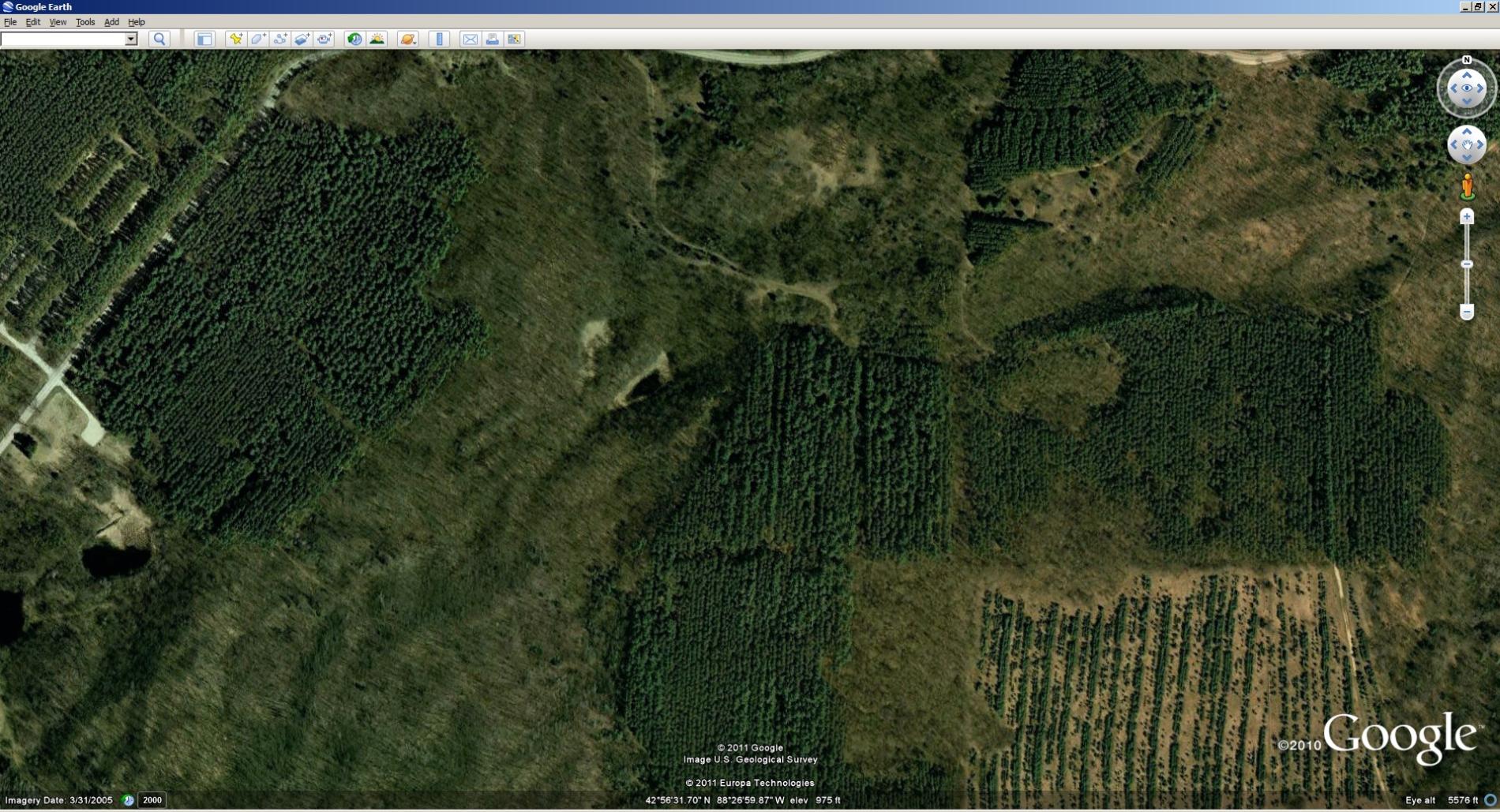
Google view of pine forest planting in various harvest states, Southern Kettle Moraine State Forest, Eagle WI. Hy 67 runs north south, Hy ZZ east west. Planted by various school groups early 60's.
butthead
"never underestimate the power of stupid people in large groups" George Carlin
02/17/2011 02:25PM
Although I'm not sure how you know that the rows are that far apart, you are right that tree plantings are typically not spaced that far apart. I still think that the rows are far too uniform to be natural. Could it be that multiple rows of tree species "A" was planted next to multiple rows of tree species "B" followed by multiple rows of tree species "A" etc...
I think the view is probably from too high of an altitude with too low a resolution to see the individual tree rows which, if I had to guess, are normally like 8 to 20 ft apart depending on the species?
I think the view is probably from too high of an altitude with too low a resolution to see the individual tree rows which, if I had to guess, are normally like 8 to 20 ft apart depending on the species?
02/17/2011 02:58PM
Earlier I compared that site and my own property, using the same scale, on Google Earth. The light color bands are the same width as my driveway – 30ft.
It could be that the plantation was thinned before logging was stopped in 1978. That was not very long ago. I still remember the controversy, and very angry loggers.
02/17/2011 05:18PM
"Shooting lanes for deer hunting?"
Ahh, that makes sense. I zoomed in on one and see something at the center of one of them. The people that made them must have a lot of impetus. Some of those spokes look to be 600 ft long. My father has three lanes, two going at angles in one direction, one in the opposite direction. But they are no more than 200ft long.
Ahh, that makes sense. I zoomed in on one and see something at the center of one of them. The people that made them must have a lot of impetus. Some of those spokes look to be 600 ft long. My father has three lanes, two going at angles in one direction, one in the opposite direction. But they are no more than 200ft long.
02/17/2011 06:35PM
My guess, it's a replanted stand. For whatever reason fire, blowdown, or more likely logging. Probably by logging company or crew by hand. Done in rows as standard practice, to make future harvest easier and promotes straight shoots for healthier branchless trees. Without seeing two photos in stereo tree size to determine age is difficult.
"Common sense is not so common" -Voltaire

02/17/2011 10:57PM
quote tremolo: "quote inspector13: "
I find patterns like this in the Lake Superior highlands more intriguing. They are in several spots from west of Silver Bay to the Tofte area. See link. Spokes in the woods
"
weird cool"
ditto. very interesting but very different.
02/18/2011 12:01AM
the spokes in the woods baffles me. at one point in my life i used photogrammetry as a part of my job as a county land surveyor. initially i would suspect that they were a part of a Guyed Mast system for a tall transmission tower, however it doesn't make sense that they would have to disrupt the ground vegetation to this extent for guy lines. i am more likely to suspect that these ground structures are a part of a radio communication system used by the military. just a guess based on other stuff that i have read.
02/18/2011 06:32AM
It has been a long time since I studied aerial photos. I still have my steroscope in my desk. But it is useless in this case.
As I am limited in working with the picture, I would tend to agree that the "rows" are a good distance apart. But I question that what you think are rows of trees are in fact, rows of cleared trees. The trees are the green spaces between the lighter colored rows. I am guessing that a precommercial thinning was done some time back in this stand of trees. The cleared rows are designed to allow the trees to grow taller, faster and bigger than if the were still competing in a dense stand.
Hard to tell.
Life is Good, Living is Better. Everlasting Life is Best! Pray for Us Amok.
02/18/2011 06:37AM
If you look at the rows, you will notice that (assuming for discussion purposes) that the sun is to the right (East) and is casting a shadow to the left of each edge of standing trees. This dark edge is adjacent to the light edge of the rows that have been cleared.
It is possible the entire stand was machine planted as previously mentioned. That would lend itself to the straight rows.
It is possible the entire stand was machine planted as previously mentioned. That would lend itself to the straight rows.
Life is Good, Living is Better. Everlasting Life is Best! Pray for Us Amok.
02/18/2011 07:17AM
My grandfather was in the CCCs in northern Minnesota. He said one of his jobs was planting trees/seedlings (I've done this as well on a smaller scale).
Basically each guy would have a basket full of seedlings on his back and a pitchfork type of tool. They would walk in a line and swing the pitchfork into the ground with one hand, grab a seedingling with the other and almost throw it into the small hole. Then close it with a kick from the boot.
They planted thousands of trees a day this way.
"I'm not superstitious. I'm a little stitious" - Michael Scott
02/22/2011 10:23AM
quote jwartman59: "the spokes in the woods baffles me. at one point in my life i used photogrammetry as a part of my job as a county land surveyor. initially i would suspect that they were a part of a Guyed Mast system for a tall transmission tower, however it doesn't make sense that they would have to disrupt the ground vegetation to this extent for guy lines. i am more likely to suspect that these ground structures are a part of a radio communication system used by the military. just a guess based on other stuff that i have read."
There was a military base near Finland MN.
12/10/2018 08:40AM
Mystery solved.
Tomahawk: "... It was even drivable around 71-72 because Leustek's were back on the Quadga Road, logging. There were also wolf trackers driving in their with antennas on their vehicles, I talked to them a few times. So, it would've had to been after 1972 when the road was bermed. The 2 catskinning crews with those 2 International TD-19 dozers were rock raking up there then north of Ferne Lake around 67-68. They had a gate very near where the rail line came in from Island River that they'd have to unlock each day before they went through then lock again after they went through and then drove their panel truck up to Ferne. ..."
12/10/2018 10:43AM
That was my first thought, inspector.
These are spaces between trees making them look like rows, they are most likely berms, probabally 7-10 feet high when they were put in by the rock rakers. Trees were planted between the berms making them look like rows. These berms settle/rot in time and will be 5-ish feet high or less many years later.
When first put in these berms are nearly impossible to walk over,
Look closely when you are in (some) pine plantation many years old, you will still see these berms even though they have really settled due to the rotting wood in them and other things.
Usually, the reason for rock racking the spoil into berms was so a mechnical tree planter could be used, but on furthur thinking, mechanical planters do not work well in the the Superior NF due to the ledge rock. Most likely the reason for this rock rakiing was to create a seed bed for the Pine seedlings, while taking away competing vegetation like Popple seedlings.
May the rivers be crooked and winding, and your portages lonesome, leading to the most amazing view.
12/10/2018 08:59PM
It's not a bog, it's high ground. And yes, the lines are around 200 feet apart---just go to the area on Google maps and zoom in and look at the scale on the bottom right of the screen. I'm wondering if it is logging slash that was pushed into windrows prior to planting. Interesting that the lines also show up in the Pagami creek burn just to the north. If they were windrows of logging slash and soil and whatnot, it's possible those would show up in the photo too.
Here's a topo.

Someone's going to have to go up there and do some ground truthing!
Here's a topo.

Someone's going to have to go up there and do some ground truthing!
12/10/2018 09:41PM
marsonite: "It's not a bog, it's high ground. And yes, the lines are around 200 feet apart---just go to the area on Google maps and zoom in and look at the scale on the bottom right of the screen. I'm wondering if it is logging slash that was pushed into windrows prior to planting. Interesting that the lines also show up in the Pagami creek burn just to the north. If they were windrows of logging slash and soil and whatnot, it's possible those would show up in the photo too.been there done that,but my memories fading a little. pretty sure it is pine plantations. There was a very good road there once. Follow Jackpines thread and it talks about that area.
Here's a topo.
Someone's going to have to go up there and do some ground truthing!"

Subscribe to Thread
Become a member of the bwca.com community to subscribe to thread and get email updates when new posts are added. Sign up Here
 Search BWCA.com
 Donate